Situating the Urban Flooding CityLab
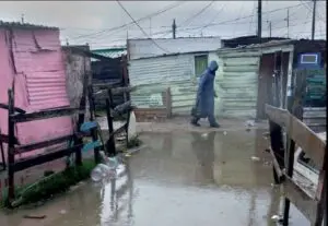
Almost 100,000 households in Cape Town live in high flood risk informal settlements on the Cape Flats, a flat, sandy, low-lying, poorly drained area subject to regular rising flooding during the winter rains. Typically about 8,000 households are displaced each winter and there are numerous negative impacts on the health and livelihoods of a considerably larger number of households each year. The Urban Flooding CityLab was initiated in 2008 in response to this problem, in order to bring together researchers and practitioners from different disciplines to understand the causes and impacts of flooding in a more holistic way and investigate how flood risk can be better managed. The activities of this CityLab have largely been concluded, but there are still a few presentations that are planned and a few research outputs that still in the process of being published.
About
The Urban Flooding CityLab was coordinated by Warren Smit. The CityLab consisted of a series of 12 seminars on various issues relating to flooding in Cape Town and the collaborative Flooding in Cape Town under Climate Risk (FliCCR) research project. The FliCCR project, funded by the International Development Research Commission (IDRC), was a collaborative interdisciplinary project led by Gina Ziervogel (Environmental and Geographical Science, UCT). Others involved in the project included Joy Waddell (Environmental and Geographical Science, UCT), Clifford Shearing and Laura Drivdal (Centre of Criminology, UCT), Julian Smit and Kevin Musungu (Geomatics, UCT), Anton Cartwright and Anna Taylor (Stockholm Environment Institute) and Gregg Oelofse and Darryl Collenbrander (City of Cape Town). The project involved working closely with City officials and community groups to understand the various perspectives of the causes of, and potential solutions to, flooding and how to overcome obstacles to proactive flood risk management. A theoretical lens of “collaborative nodal governance” was adopted.
CityLab results
The fieldwork included participatory GIS surveys and ethnographic fieldwork in four informal settlements. The project highlighted that most of the blockages to effective flood risk management are institutional rather than technical.
The outputs of the project included 5 journal articles, 10 postgraduate theses, 8 reports and 11 conference presentations (there are a further 3 journal articles and 2 book chapters that are still in the process of being finalized for publication, and a few more conference presentations are planned). In addition, a 32-page booklet on flooding in Cape Town, entitled Rising Waters: Working Together on Cape Town’s Flooding, was published by ACC, and was widely circulated to policymakers, practitioners and informal settlement communities in Cape Town. A number of workshops to bring City officials, NGOs and community groups together were held, notably the flood dialogue workshop in March 2013 and a two-day workshop in May 2013. Through these workshops and through the dissemination of the research findings, the project helped broaden the perspectives of key stakeholders and make them more proactive in collaborating with others (this was particularly highlighted at the workshop in March 2013).Some of this has been tangibly reflected in the work of the City of Cape Town’s Flood and Storms Task Team and their attempts to collaborate with Ward Committees. Some of the reports that were produced had very specific impacts, for example, the report on the Graveyard Pond informal settlement helped persuade the City that the community needs to be relocated to area that is less at risk of flooding.
Publications
A number of publications resulted from the CityLab. A selective list is available below.
Books:
African Centre for Cities. (2013). Rising waters: Working together on Cape Town’s flooding. Cape Town: African Centre for Cities.
Journal articles:
Ziervogel, G., Waddell, J., Smit, W., & Taylor, A. (2014). Flooding in Cape Town’s informal settlements: Barriers to collaborative urban risk governance. South African Geographical Journal. doi: 10.1080/03736245.2014.924867
Musungu, K., Motala, S., & Smit, J. (2012). Using multi-criteria evaluation and GIS for flood risk analysis in informal settlements of Cape Town: The case of Graveyard Pond. South African Journal of Geomatics, 1(1), 77-91.
Musungu, K., Motala, S., & Smit, J. (2012). GIS data collection for flood risk management. PositionIT, April/May, 66-72.
Ziervogel, G., & Smit, W. (2009). Learning to swim: Strengthening flooding governance in the City of Cape Town. Paper presented at Conference on the Human Dimensions of Global Environmental Change “Earth System Governance: People, Places and the Planet”, Amsterdam, Netherlands, 2-4 December.
Newspaper articles:
Waddell, J., Smit, W., Ziervogel, G., & Drivdal, L. (2013). The trickle-down effect. Cape Times, 24 June, p. 11.